In the 1970s, in France, engineers from the school of "Arts et Métiers" together with Peugeot and Renault conceived a graphical method for analysing motifs, adapted to the characterization of functional and structured surface texture. The great interest of this method is that it takes the functional requirements of the surface into account and attempts to find relationships between peak and valley locations and these requirements.
1. Topological characterization of surface motifs
This method, known as CNOMO E00.14.015.N had a great success in French industry and ended up being incorporated into an international standard in 1996 [ISO 12085]. During the past ten years, many players have tried to extrapolate this method to 3D, with little success. It was only when methods derived from image analysis were applied to areal surface texture that the benefits of the motifs method were rediscovered [SCOTT 1997, BARRÉ 2000]. This method is now officially integrated into the ISO 25178 standard, as a method of discriminating between significant peaks and holes, and equally as a method of characterizing 3D motifs.
The method, currently called segmentation, is based upon the application of a watersheds algorithm, associated with an algorithm for simplifying graphs that describe the relationships between individual points (Wolf pruning) [WOLF 1993].

Details on feature parameters
can be found in [BLATEYRON 2013b] (chapter 3 of [LEACH 2013]).

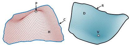
The name "Motifs" is used for either hills (H) or dales (D). A dale is surrounded by a ridge line (R) and its minimum point is the pit (V). A hill is delimited by a course line (C) and its maximum point is a peak (P).

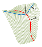
Saddle (S) points are located at the intersection between course lines and ridge lines.

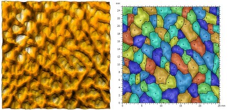
Above: Segmentation of a grained surface. The black crosses show the location of the peaks on each motif. Each motif represents a constituent element of the surface texture, capable of affecting the functionality of the part (lubrication, wear, contact, etc.) On the right image, each motif is represented by a different colour. MountainsMap® makes it possible to count and quantify the motifs, to sort them into open and closed motifs, and to measure their area, mean depth, volume, etc.
2. Areal feature parameters
Segmentation is also a powerful tool for identifying significant peaks and significant pits, and is recommended when calculating peak density and peak curvature. ISO 25178 defines two new parameters that replace Sds and Ssc that were defined in the SurfStand report.
Spd, density of peaks
Spc, mean peak curvature
From the significant peaks and pits, it is then possible to define robust heights:
S5p, five-point peak height
S5v, five-point pit height
S10z, ten-point height
With segmentation, these parameters become much more relevant than they were previously (when they were applied in accordance with the definitions in preceding European reports).
In addition, specific parameters have been created to quantify the area and mean volume of motifs identified by segmentation, distinguishing between open and closed motifs, depending upon whether or not they touch the edge of the image.
Sha, mean hills area
Sda, mean dales area
Shv, mean hills volume
Sdv, mean dales volume
Feature parameters are included in the Particle Analysis optional module of MountainsMap, and in MountainsMap® Premium.